How GIS Supports Countering Terrorism

𝐈𝐧𝐭𝐞𝐫𝐨𝐩𝐞𝐫𝐚𝐛𝐢𝐥𝐢𝐭𝐲 𝐃𝐫𝐢𝐯𝐞𝐬 𝐭𝐡𝐞 𝐟𝐮𝐭𝐮𝐫𝐞 𝐨𝐟 𝐉𝐨𝐢𝐧𝐭 𝐆𝐄𝐎𝐈𝐍𝐓 𝐎𝐩𝐞𝐫𝐚𝐭𝐢𝐨𝐧𝐬
February 17, 2022„The geospatial platform is able to project the terrorist’s pre-attack activities in a space-time trajectory.”
The terror incident in Paris has sparked renewed interest in the deployment of technologies to counter terror. Monitoring and anticipating terror plans is the key to staying ahead of the next unknown attack. Despite the definition and dimensions of terrorism changing over the decades, GIS has been found to be a very effective tool. It has the capability of preventing, predicting or countering terrorist attacks, while helping to strategize and support ground level combat operations. .


GIS Applications to Counter Terror
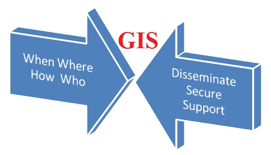
GIS application to counter terror begins with monitoring and surveillance to predict the four components (when, where, how, who) of terror activity. It moves on to disseminate critical information through the various public service agencies, homeland security systems and intelligence departments.
In the event of a terror attack, geospatial tools and technologies help to secure citizens and property as well as support the ground combat operations.
GIS applications to counter terror
An act of terrorism usually has a planning cycle. It does not happen out of the blue. Any terrorist activity thus displays distinct temporal trends, as pre-attack activities occur over a span of time. At the same time, the planning exposes a bimodal spatial pattern of both, preparation and target selection.
GIS Tools and Technologies in Various Stages of Counterterrorism
An act of terrorism usually has a planning cycle. It does not happen out of the blue. Any terrorist activity thus displays distinct temporal trends, as pre-attack activities occur over a span of time. At the same time, the planning exposes a bimodal spatial pattern of both, preparation and target selection.
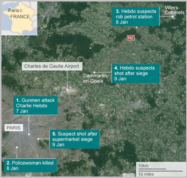
Sequence of events during the Paris terrorist attack (7-9th January, 2015) Source: BBC news.
The geospatial platform is able to project the terrorist’s pre-attack activities in a space-time trajectory. This information is available in real time for a decision support system.
Stages in GIS Implementation for Counterterrorism
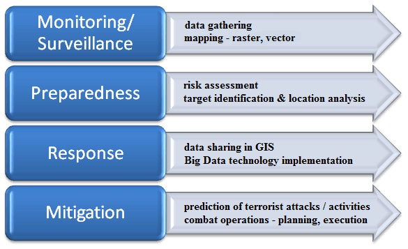
Stages in GIS implementation for counterterrorism
Monitoring / Surveillance: Terrorist movements, cross-border money laundering, unnatural terrain or ocean activities have a spatial component. Trends and hot spots are overlaid on maps for analyzing patterns of terrorist activities in real time.
Preparedness: Based on the above, risk assessment is done. Vulnerable targets, personalities and locations are identified. Terrorists / terror groups with sudden movements or increased activities are analyzed and correlated spatially with political, ethnic or other factors.
Response: GIS enables sharing of data and analysis across agencies to build a tactical strategy. Potential attacks can be prevented with the use of geospatial tools and technologies that have become core to police surveillance and military intelligence.
Mitigation: Predictions of potential terror activities help to build resilience against damage to human life and property. Emergency response uses existing base maps and satellite imagery overlaid with crowdsourced information, drone surveillance data, terrorist locations and geo-tagged social media activity in real-time.
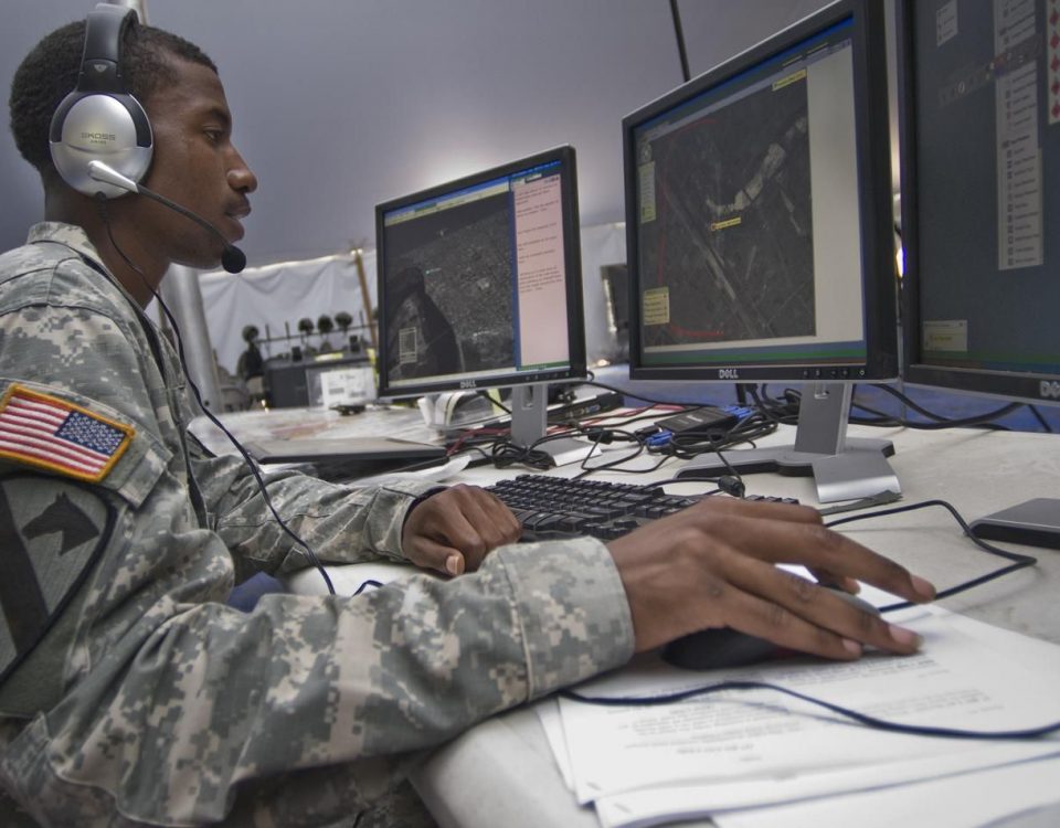
During anti-terrorist operations, once again GIS technology is core to combat actions. Maps are the most critical element for monitoring terrorist movements, communicating with ground operations and actual police trail or combat. Satellite imagery and LiDAR data is used to understand terrain and strategize with high precision. UAVs are used to identify positions, photograph or carry support to inaccessible areas.
Geospatial for Countering Terrorism Vis-a-vis Geospatial for Crime Analysis
GIS technology enables a seamless flow of information between intelligence and law enforcements agencies for monitoring and combat operations, at the local or neighborhood level. However, there is need to differentiate the use of geospatial for countering terrorism from its use in crime mapping and analysis.
GIS applications for crime mapping and analysis GIS applications for countering terrorism
i) used by law enforcement agencies at national, federal, local /city levels
ii) crime analysis and mapping is localized
iii) profiling and analysis considers local factors
iv) applies local data, road maps, traditional GIS software and tools, GPS technology
v) it is not always possible to predict crimes using GIS, where there is no previous record
GIS applications for countering terrorism
i) used by centralized anti-terrorism, security and intelligence agencies
ii) monitoring and predictions arenational / global
iii) surveillance and predictions are based on international geo-politics and terror analysis
iv) makes use of Big Data, advanced GIS software and tools, mashups, sophisticated GIS technologies like UAVs and RS
vi) acts of terrorism are planned by terrorists / terror groups, and can be predicted using GIS technologies combined with intelligence
Areas of GIS Application in Counterterrorism:
- Terrorist / Terror Group Surveillance
- Special Reconnaissance
- Intelligence gathering and visualization
- Military / Police operations
- Contingency Planning
- Timely decision support
- Real-time management of field operations
- Accuracy of rapid response
- Development of training and combat plans
- Area assessment – terrain, layout, location, roadmap
- Monitoring of potential targets
- Countering terrorist financing
- Geospatial Intelligence (GEOINT)
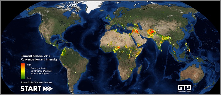
Mapping of Terrorist attacks (2013) Source: Global terrorism database
GIS Tools and Technologies in Use
Maps – aerial maps, satellite maps, road maps, bathymetric maps, hydrographic maps, geologic maps, soil maps, city utility network maps, political maps, thematic maps (military installations, nuclear plants, vulnerable sites) and so on.
Satellite Imagery
LiDAR
UAV (Unmanned Aerial Vehicle) or Drones
GPS technology
Analysis Tools and Techniques – Tapestry segmentation, Location analyses, Network analysis, radius buffering, 3D modeling of targets, hot spot mapping, spatial querying, spatio-temporal analysis, exploratory spatial data analysis, linear distance analysis, and so on.
Community mapping – crowdsourcing, Participatory GIS, geo-tagged social media activity
Technology mashups using Big Data platform
